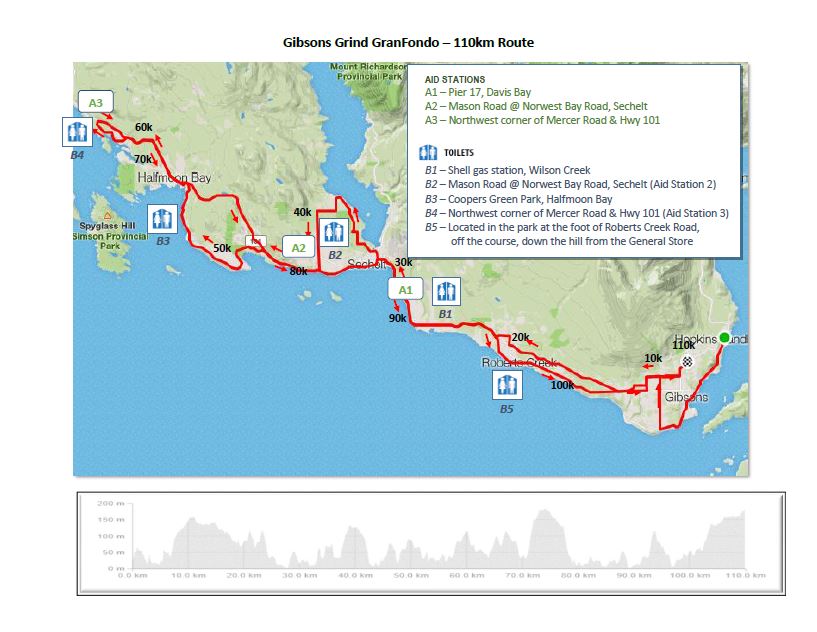
110 Km Route
At 110 km, this route has over 1700 meters of climbing (comparable to the RBC GranFondo Whistler)
The 110 km route follows the 50 and 70 km routes (see those descriptions for more details of those portions of the route) until the second aid station at the top of Mason Road. The route then heads down Mason to Highway 101 and follows Highway 101 until RedRooffs Road where it leaves the highway behind for a stretch of undulating rural road with scenic peeks of the ocean. Riders follow the water until it connects again with Highway 101 heading for the top of the route at Mercer Road and the third aid station. Riders then start the trek back, reconnecting with Highway 101 and following Highway 101 through some significant climbs until it recombines with the 70 km route just before Sechelt. After passing through the southern shores of Sechelt, riders head for Roberts Creek and then onto the finish at Persephone Brewing Company and well deserved refreshments.
The 110 km route follows the 50 and 70 km routes (see those descriptions for more details of those portions of the route) until the second aid station at the top of Mason Road. The route then heads down Mason to Highway 101 and follows Highway 101 until RedRooffs Road where it leaves the highway behind for a stretch of undulating rural road with scenic peeks of the ocean. Riders follow the water until it connects again with Highway 101 heading for the top of the route at Mercer Road and the third aid station. Riders then start the trek back, reconnecting with Highway 101 and following Highway 101 through some significant climbs until it recombines with the 70 km route just before Sechelt. After passing through the southern shores of Sechelt, riders head for Roberts Creek and then onto the finish at Persephone Brewing Company and well deserved refreshments.
Road Hazards
There are some steep hills on the route. Some are in excess of 8% and quite long. This can result in high speeds so make sure your brakes are in good working order. A few of the hills have sharp turns or intersections with stop signs at the bottom. Please be careful.
Traffic - It is a weekend and this is not a closed course so there will be traffic on the roads. Be careful and make sure that it is safe to proceed. Look before making any turns and lane changes, or when approaching uncontrolled intersections.
Condition of the road - The shoulder along the routes is in some places narrow and in less than perfect condition. Stay alert for hazards, and if you are riding in a group and you are up front, pay extra attention and clearly call out hazards out.
Watch out for wildlife. This is a rural area. Deer and other wildlife are not unexpected.
GPX,KML,PDF Files |
|
Downloadable GPX, KML and PDF data files for your gps, google earth, phone devices
| ||||||||||||||||||

